UPDATE: 6:20 p.m.: Five people were rescued from a flooded home on Reeds Island in Hilo today after a nearby gulch overflowed.
According to the county, they weren’t injured and were taken to a shelter at Waiakea High School.
Also, a county helicopter was used today to rescue two campers who were trapped overnight in Waipio Valley. The campers also were uninjured.
UPDATE 5:45 p.m.: As of 5 p.m. Thursday, a hurricane warning for the Big Island was downgraded to a tropical storm warning.
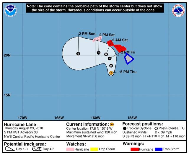
Hurricane Lane was about 180 miles southwest of Kailua-Kona with maximum sustained winds of 120 mph, moving to the west-northwest at 6 mph.
A flash flood warning for the island and high surf warning for south- and west-facing shores remained in effect.
UPDATE 2:45 p.m.: Hurricane Lane has been downgraded to a Category 3 storm, just below the threshold for Category 4, but is still a very powerful storm as it continues to threaten the state.
As of 2 p.m. today, the center of the storm was 190 miles south-southwest of Kailua-Kona with maximum sustained winds of 125 mph and gusts of up to 160 mph. It was moving in a north-orthwesterly direction at 6 mph.
“It’s to the west of the Big Island and the Big Island is lucky that it’s stayed to the west. It’s really put Maui and Honolulu in the crosshairs,” Melissa Dye, National Weather Service forecaster said this afternoon.
Hawaii County Civil Defense Director Talmadge Magno told residents, especially those of East Hawaii, should be prepared for more torrential rainfall.
“We’re only partway through this whole storm, and so the rainfall is gong to continue; we’re concerned about that. Everything is saturated and flowing on the surface now. The projected forecast is for the winds to start this afternoon so we’re watching for that and the swell is supposed to start picking up around the same timeframe,” Magno said.
Noting that some areas received 12 inches of rainfall in 12 hours, Magno said, “That’s maybe half of what’s forecasted. I think we got a lot more rain to come.”
Magno said he was watching for floodwaters to raise water levels in local rivers.
“They receded this morning a bit,” he said.
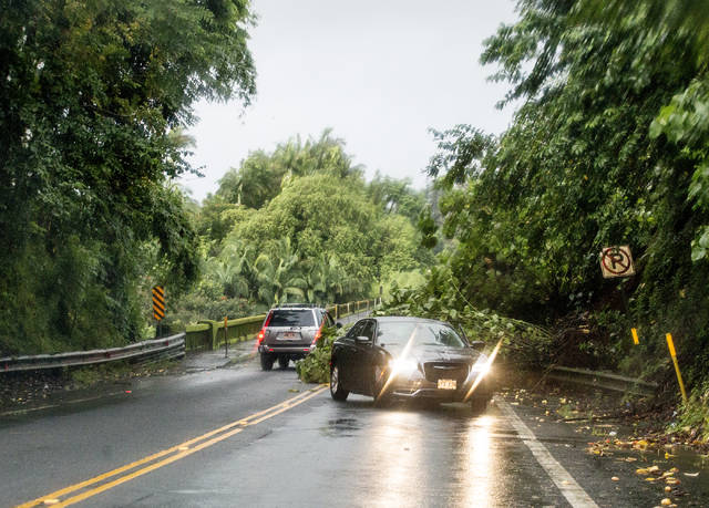
Hawaii Belt Road (Highway 19) was reopened after a landslide closed it this morning near Honomu, but the closure of Akoni Pule Highway (Route 250) at the 24-mile marker could last into tomorrow, according to the state Department of Transportation.
A large eucalyptus tree fell onto the main thoroughfare in and out of North Kohala in Kapaau this morning, blocking both lanes.
DOT spokesman Tim Sakahara said it was unsafe for workers to remove the large tree from the highway due to wind and the risk of other trees falling.
“It may be tomorrow,” Sakahara said.
Noting that debris and landslides can happen at any point, Ed Sniffen, deputy director of the state Highways Division, said that although Highway 19 has been reopened, he advises motorists “if they don’t have to be on the road don’t be.”
Sniffen also said that even if the island doesn’t experience hurricane-force winds, tropical-storm force winds of 40 mph are sufficient to topple albizia trees.
UPDATE 11 a.m.: At 11 a.m. the center of Hurricane Lane was 160 miles southwest of South Point, 230 miles southwest of Hilo and 195 miles south-southwest of Kailua-Kona.
It remains a potent Category 4 Hurricane with maximum sustained winds of 130 mph, moving northwest at 7 mph. Hurricane-force winds extend outward up to 35 miles from the center and tropical-storm-force winds extend outward up to 140 miles.
A hurricane warning, high surf warning and flash flood warning remain in effect for the Big Island.
Flooding and road closures continue to be reported in East Hawaii.
UPDATE 10:20 a.m.: Police are advising the public to remain off the streets and roadways in the South Hilo District due to extreme weather from Hurricane Lane that is causing flooding and heavy runoff.
Do not drive on the roadways and streets unless absolutely necessary.
All county parks are closed due to the weather conditions. County crews are posting signs and barricades at problem areas. Do not enter these high risk areas.
Akoni Pule Highway (Route 270) also remains closed near the 24-mile marker in North Kohala due to a landslide. The estimated duration of the closure is not known. State Highways personnel are currently on-scene to assess options.
Motorists are also being advised to avoid Kaalaiki Road just above Naalehu in Ka‘u, as the road is closed due to flooding.
Highway 19 had one lane open this morning near the 13-mile marker near Honomu after a landslide.
PREVIOUS:
“Torrential rain soaking the Big Island” is how the National Weather Service headlined its 5 a.m. update on Hurricane Lane today.
The storm has all but stalled over the Big Island, causing rains, especially in East Hawaii, that has caused flash flooding and road closures including Highway 19 near Honomu and the Hilo Bayfront Highway.
A flash flood warning is in effect for the Big Island and the National Weather Service cautions islanders to avoid unnecessary travel because of “multiple road closures” and “additional rainfall … approaching from the southeast.”
As of 8 a.m., Lane was 175 miles southwest of South Point, 240 miles southwest of Hilo and 175 miles south-southwest of Kailua-Kona.
Maximum sustained winds had diminished somewhat, at 130 mph, but that still makes the storm a powerful Category 4 hurricane. It has slowed considerably in its approach to the Hawaiian Islands, moving to the northwest at 7 mph.
A hurricane warning remains in effect for Hawaii, Maui and Honolulu counties, and a hurricane watch remains in effect for Kauai County.
Steady weakening is forecast during the next couple of days. Lane is expected to remain a hurricane as it draws closer to the islands.
Radar and rain gauges showed heavy rain continuing from the windward Kohala slopes to South Point.
As of 7:45 a.m. Hilo International Airport’s rain gauge showed 13.28 inches had fallen in the prior 24 hours. Other gauges with significant rainfall include: Waiakea Experimental Station, 17.68 inches; Waiakea Uka, 12.43 inches; Hakalau, 11.36 inches; Pahoa, 5.86 inches; Glenwood, 8.16 inches; Kulani, 8.10 inches. Some leeward areas received significant rainfall, as well, including Kapapala Ranch, 4.51 inches; and Pahala, 3.74 inches.
West Hawaii saw significantly less rainfall, although Waikii measured 1.54 inches, Kahua Ranch saw 1.96 inches, Ahumoa had 1.73 inches and normally parched Waikoloa measured 0.46 inches.
“We’re looking for winds and heavy rainfall to persist the next couple of days,” National Weather Service meteorologist Deanna Marks told emergency workers at county Civil Defense headquarters in Hilo this morning.
Marks said thunderstorms remain a possibility.
Lane is expected to produce total rain accumulations of 10 to 20 inches, with localized amounts in excess of 30 inches over the Hawaiian Islands.
A high surf warning is also in effect for south-facing shores and surf is expected to rise between 7-10 feet today, rising to 10-15 feet tonight, then 10-20 feet on Friday.
As Lane is slow-moving, large swells generated by the hurricane will severely impact the Hawaiian Islands over the next couple of days. These swells will produce very large and damaging surf along exposed west and south facing shorelines. A prolonged period of high surf will likely lead to significant coastal erosion.
The combination of a dangerous storm surge and large breaking waves will raise water levels by as much as 2 to 4 feet above normal tide levels along south and west facing shores near the center of Lane. The surge will be accompanied by large and destructive waves.
Possible impacts include ocean water sweeping over shorelines and large breaking waves affecting harbor entrances and potential damage to coastal properties and infrastructure, including roadways, docks, piers, ramps, and boats.
Schools, government offices and courthouses remain closed for the week. Big Island post offices are closed for the day.
Hawaii Electric Light Co. has also closed its customer service and engineering offices to walk-in customers today.
In the event of power outages, crews will be dispatched only after the storm has passed and when it is safe to do so, the utility said in a statement.
Outage notifications will be posted on the company’s Twitter account @HIElectricLight with the hashtag #BigIslandOutage.
The community is reminded to stay at least 30 feet away from downed power lines, as they may have electricity running through them and may be dangerous. To report power downed power lines and power outages, customers may call 969-6666.
“Safety is our top priority. We encourage everyone to stay safe and follow the guidance of Civil Defense officials,” said HELCO spokeswoman Kristen Okinaka.
Email John Burnett at jburnett@hawaiitribune-herald.com


